
15 June 2015
Flood Threat Growing for Texas
Posted by Dan Satterfield

From the NASA Terra Satellite today in true colour. Click image for a 1km resolution image.
There is growing concern that a tropical cyclone may be forming in the Gulf tonight, and it will likely impact the Texas coast by late Monday. This system will probably not have time to reach hurricane strength but it does not matter since the threat is heavy flooding rains. While it will probably cross the coast well SW of Houston the heavy rains may affect the entire Texas coast, and with the very saturated ground near Houston and to the northwest into San Antonio and Austin, this is a serious threat.
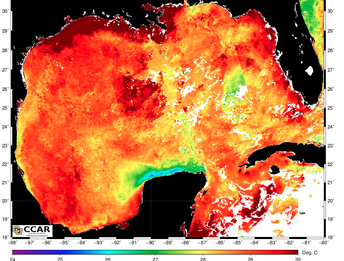
Current sea surface temps from the NASA Aqua satellite. Notice the very warm water along the Texas Coast.

The Gulf water is unusually warm (as are the rest of the world’s oceans on whole. This means more water can evaporate into the atmosphere and thus more rain.
Something to remember, is that wind kills few people in a tropical storm or hurricane. It’s storm surge on the coast and flooding rains inland, and if you don’t believe me, ask anyone from New Orleans. The Gulf of Mexico is very warm right now, warmer than usual in June, and this increases the threat of heavy flooding rains. So if you are in Texas, pay attention to the radar and don’t worry as much about the wind, or even where the center of the storm will make landfall. From satellite data this evening and model guidance, it looks like the wettest part of this system will be on the northern side, so a landfall on Padre Island could still cause floods in Houston and up to Austin. The warm oceans mean that where heavy rains fall, they can be exceptionally heavy.
One way of looking at potential rainfall is to look at what we meteorologists call precipitable water. When precipitable water starts approaching 50mm watch out!
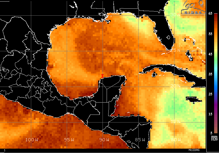
From CIMMS at Uni. Wisc. Satellite estimates of precipitable water using different IR wavelengths.
I’ll leave you with a discussion from the NOAA Weather Prediction Center. This discussion is mainly for meteorologists but I think it is spot on, and covers a few things I did not mention above about model guidance.
QPF- precip amounts
GFS= US Longer range numerical model
ECM- European longer range model
CMC- Canadian model.
TPW- total precipitable Water.
QUANTITATIVE PRECIPITATION FORECAST DISCUSSION
NWS WEATHER PREDICTION CENTER COLLEGE PARK MD
603 PM EDT SUN JUN 14 2015
...WESTERN GULF STATES....

MAIN FOCUS IN THIS REGION WILL BE THE TROPICAL PLUME OF MOISTURE
MOVING NORTHEAST ASSOCIATED WITH THE POTENTIAL GULF TROPICAL
SYSTEM. REGARDLESS OF WHAT HAPPENS WITH THIS POTENTIAL TROPICAL
SYSTEM...THERE SHOULD EB A HEAVY RAIN THREAT ACROSS PORTIONS OF
SOUTHEAST TEXAS AS ALL THIS MOISTURE IS TRANSPORTED NORTH. MODEL
DIFFERENCES FIRST EXIST WITH HOW QUICKLY CONVECTION DEVELOPS AHEAD
OF THE SYSTEM MONDAY NIGHT. WPC BUMPED UP VALUES A BIT FROM THE
PREVIOUS FORECAST...WITH THE ECMWF SEEMING ON THE DRY SIDE GIVEN
THE EXPECTED MOISTURE AND INSTABILITY PRESENT ACROSS THE REGION.

NEXT QUESTION IS WHERE DOES THE SYSTEM TRACK. PRETTY LARGE SPREAD
AMONG THE GUIDANCE...WITH THE CMC A FAST OUTLIER...AND THE GFS
MORE ON THE WEAKER AND WESTERN EDGE OF THE GLOBAL GUIDANCE. THUS
WPC QPF FAVORED A SOLUTION MORE BETWEEN THE 0Z/12Z ECMWF...THE 12Z
UKMET AND THE 12Z GFS ENSEMBLE PROBABILITIES FOR DAY 2. BY DAY 3
THE GFS ENSEMBLES BECOMES LESS USEFUL AND THE FORECAST WAS CLOSER
TO THE ECMWF/UKMET CONSENSUS. THESE TWO HAVE BEEN PRETTY
CONSISTENT WITH THEIR TRACK AND QPF AXIS...AND ARE PRETTY SIMILAR.
THIS CONSENSUS ALSO CLOSELY MATCHES THE PREVIOUS WPC QPF FORECAST.
THE ECMWF CONTINUES TO BE THE SLOWEST OF THE GUIDANCE...THUS USING
THE UKMET IN THE CONSENSUS HELPED SPEED THE SYSTEM UP SOME. IT
SHOULD BE NOTED THAT EVEN THOUGH CONFIDENCE ON AN AREA OF HEAVY
RAIN IS HIGH...GIVEN THE SPREAD...THE EXACT LOCATION AND TIMING IS
A LOW CONFIDENCE FORECAST.
 Dan Satterfield has worked as an on air meteorologist for 32 years in Oklahoma, Florida and Alabama. Forecasting weather is Dan's job, but all of Earth Science is his passion. This journal is where Dan writes about things he has too little time for on air. Dan blogs about peer-reviewed Earth science for Junior High level audiences and up.