
1 June 2016
Herbicides, Critical Source Areas, and Vegetated Buffers
Posted by John Freeland

Soybean field with abundant marestail , Lenawee County, Michigan (October, 2015).
Waging Chemical Warfare on Weeds
Last fall, while on one of my country road walking routes, I noticed an advanced infestation of marestail (Conyza canadensis) in a soybean field. Evidently, this weed, and others, is becoming herbicide-resistant. A new agricultural herbicide called Acuron (link goes to manufacturer’s website) is on the market, and in some fields.
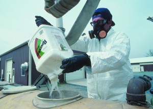
A Maryland farmer loads Roundup (glyphosate) herbicide into sprayer tank (NRCS Photo)
Aquatic Habitat Concerns and New EPA Registration Conditions for Acuron
Because it contains another widely-used herbicide called atrazine, there is some concern over Acuron’s unintended effects on aquatic resources. From the EPA – Revisions to Ground and Surface Water Advisory Statements and Soil Organic Matter Section, October 7, 2015:
This product contains atrazine, which has been shown to be toxic to aquatic invertebrates…This product has a high potential for reaching surface water via runoff for several months or more after application. A level, well-maintained vegetative buffer strip between areas to which this product is applied and surface water features such as ponds, streams, and springs will reduce the potential loading of bicyclopyrone, atrazine, S-metolachlor and mesotrione from runoff water and sediment. Runoff of this product will be reduced by avoiding applications when rainfall or irrigation is expected to occur within 48 hours.
The Significance of Critical Source Areas
Not all land surface areas share equally in contributing runoff and pollutants to surface waters. Fine-textured soils with high clay content that are found in low landscape positions receiving drainage from soils higher in the landscape tend to saturate and generate surface runoff sooner than other areas of the watershed during a rain event. This phenomenon has been called the “variable (or partial) hydrologic source areas” concept (Dunne and Black 1970). Where these areas coincide with a pollutant applied to soil, a pollution transport mechanism is in place. These are Critical Source Areas (CSA).
A good fact sheet summary prepared by the NRCS, Recognizing Critical Source Areas describes CSA with some discussion of field research showing relatively small percentages of a watershed may actually contribute phosphorus to waterbodies. These areas in the landscape are recognizable and mapable using GIS, soil survey, topography, and digital elevation data. Candidly, the fact sheet also indicates that, in some instances, best management practices used in fields to protect CSAs were mistakenly installed in non-CSA areas.
The area outlined in red in the figure below most likely qualifies as a CSA. It is mapped as the Pewamo clay loam, it is adjacent to a stream, and it’s darker soil appearance strongly suggests that it collects water and accumulates organic matter, compared to the lighter soils surrounding it.

A likely Critical Source Area adjacent to an intermittent stream, Monroe county, Michigan.
What appear to be two artificial drainage features are visible apparently connecting the CSA to the stream. Obviously, this is part of the field is a problem area (due to wetness) for the farmer. From a water quality perspective, this CSA should not be in crop production, and instead should be planted with a permanent vegetated cover.
Opportunities for CSAs
For those (like me) interested in restoring wetlands, which offer ecological services including better water quality, nutrient retention, less flooding, enhanced wildlife habitat and more, CSAs are excellent restoration sites. It isn’t difficult to find CSAs on aerial photographs and other available GIS data layers. The difficult part seems to be in developing policies and incentives needed to redirect their use from food production to ecological services, including water resource protection.
Reference
Dunne, T. and R. D. Black. 1970. Partial area contributions to storm runoff in a small New England watershed. Water Resour. Res. 6:1296-1311.
 John Freeland earned a PhD in Soil Science (Pedology) at North Dakota State University and is a consultant working in the private sector. He has published soils research and taught at the high school and college levels. John is interested in wetlands, soil genesis, science communication, the intersection of art and science, and soil-water-landscape processes. John lives near the Ohio-Michigan border and plays bass in multiple music projects.