
Sections
Changing shapes, changing currents
Tectonics, wind and weathering
Planetary atmospheres move in complicated patterns even one as featureless as a pool ball, especially so if the planet spins (Figure 2.2). Solar warming varies with latitude to establish temperature gradients, so air varies in its density. As well as flowing laterally, it moves up and down and in both cases transports its heat content. Its convective flow establishes giant Hadley cells in a belt straddling the planet’s equator, thereby allowing higher latitude air to move semi-independently and creating pressure variations at the surface. Systems of high and low pressure further disrupt simple energy flows, any motion breaking down into vortices. Partially drown a world in liquid water, and there is yet more complexity. Winds drag surface currents, again in a complex way due to both the nature of the drag and the influence of Coriolis Force. Evaporation charges air with an extra energy content in the form of water’s latent heat of vaporisation that is eventually discharged by condensation after it has moved to cooler climes. Both evaporation and freezing of salty seas produce pure water vapour and ice and both leave behind a denser brine. It sinks to draw in surface water as a replacement in two main zones; one where evaporation is high, around the equator, the other where freezing is most likely, around the poles of rotation. So the deep oceans convect as well, and this transmits even vaster amounts of heat, albeit far more slowly than does the atmosphere. Such heat eventually transfers to moving air and is ultimately lost by radiation to space. Even on an absurdly simple planet, climate is exquisitely complicated. Given what mathematicians now know about chaos in perfect but non-linear systems that involve motion, and which experimental evidence in microcosm supports, it is quite likely too that climate on an otherwise numbingly boring planet is inherently unpredictable.
Our world is the most interesting object in the known universe, objectively because its surface is water-rich and it generates its own energy deep inside, and subjectively because we live on it. Not only that, its radiogenic heat interacts with the rocks of the mantle in yet another complex fashion; mantle rock melts only partially to form magmas that differ from their source in composition and density. In turn the magmas cool and solidify to form a distinct crust of ocean-floor basalt that caps a solid outer lithosphere above a zone of near-melting in the upper mantle. Were this outer layer identical to the rest of the mantle, its continual generation would be matched by equally continual resorption, and not much would happen. But the differentiated basalt becomes super-dense as it drives down, so adding a gravitational pull to the heat-induced push that its genesis initiates. Not only that, but the basalt rock reacts with ocean water to become cold and hydrated. Increasing temperature drives off the water deep in subduction zones; a process that induces the overlying lithosphere, and sometimes the crust itself, to melt in a subtly different way from primary mantle melting. These secondary magmas may evolve to produce virtually indigestible, lower density continental crust. Continents grow and stay at the surface, inevitably to produce a sharp division in the overall topography of the planet. Deep ocean basins are flooded, while continents, for the most part, rise to form elevated land.
Mantle dynamics is far from mechanical. The magmas that form are not simply silicate melts. They are charged to some degree with gases other than water, mainly sulfur oxides and CO2, which emerge to mix with air, particularly from volcanoes that rise above sea level. Together with dust generated by explosions and vast amounts of water vapour, the exhaled gases modify the solar energy balance. They also react with exposed continental rock to weather it. As well as the circulation systems there are interwoven chemical interactions, and all feed-back in some way to climate. That aspect figures here and in the next chapter. But the dominant feature of the mantle’s interaction with ocean and atmosphere transmission is that its enduring products, continents, continually drift, collide and break apart.
Changing shapes, changing currents
Today’s configuration of continents relative to oceans is unique. Because ocean currents, which carry lots of heat and therefore dominate long-term climate, are constrained by the positions of continents, the general aspects of climate are always never to be repeated novelties. One hemisphere is now almost completely oceanic, while the other has two huge continental masses that virtually envelope the north pole and extend longitudinally to within 40° of the south pole. Although elements of the pool-ball ocean circulation pattern can be made out, the more so in the Pacific (Figure 2.2b), there are three fundamental differences. Surface currents in the Pacific have little influence on the northern polar sea, while warm North Atlantic water flows directly to the Arctic from the tropics. That is today dragged northwards against Coriolis Force by the sinking of cold brine at the fringe of the Arctic sea ice (but see Part VII). The inexorable winds in the equatorial Hadley cells drive a westward flow of surface currents across the ocean tropics, but its full power is diverted by Central America, east Asia and Africa lying athwart its path. That power focuses elsewhere, adding to ocean circulation at mid-latitudes. The gap between Antarctica and the southern tips of South America, Africa and Australia coincides with the pool-ball west-wind belt south of latitude 40°S. All surface water in the southern oceans is dragged eastwards in a circumpolar current that just about isolates the climate of Antarctica from the rest of the planet. Antarctica is locked at present into frigid conditions by two factors. Warm currents rarely reach its shores and the South polar high-pressure system drives cold air outwards from the pole. Climatically, the North and South poles are very different with the present continental set up.
Two small shifts in continental position might greatly transform ocean circulation. If the Isthmus of Panama were to be breached, Atlantic and Pacific tropical currents would merge, and if Cape Horn were linked across the Drake Straits to Antarctica, that would stop the circum-polar current. A relatively tiny geographic change would transform the controlling elements of climate out of all recognition. Both form decisive elements in the emergence of the climate of the last 35 Ma, but that must wait until Chapter 17.
Charles Lyell posthumously took some stick from me in Chapter 5, for his demanding gradualism in the Earth’s evolution, thereby emasculating the genius of James Hutton. Lyell was not totally conservative, however, and had his moments of speculation and prescience. Before he published his monumental Principles of Geology in 1837, it was clear that Britain at least had experienced very different climatic conditions in the distant past – the tropical coal forests of the Carboniferous and the aridity of the Permian and Triassic. Long before any widespread contemplation of continental drift, Lyell tinkered with the consequences of repositioning the existing continents. He envisioned two extreme possibilities: all continents centred on the equator, and two clumps at either pole – extreme heat and extreme cold respectively. These form the basis for two of three general ‘thought experiments’ that simplify the world to one huge island continent set in a global ocean; ‘ring world’, ‘cap world’ and the third, where continental mass is clumped N-S along a meridian, ‘slice world’ (Figure 16.1).
 Figure 16.1 Continental crust distributed as a polar cap, an equatorial ring and a slice along lines of longitude
Considering these land-ocean configurations purely in terms of variations in solar heating with latitude, cloud cover, precipitation and evaporation, and snow and ice cover helps us visualise some general possibilities (vegetation does not appear in these scenarios). ‘Cap world’ is the easiest case. Bare rock and soil have higher reflectivity or albedo than water, so less solar radiation is able to heat up the polar land surface than would occur with a polar sea. Already prone to being cool, high-latitude regions of a ‘cap world’ become colder still. If ice sheets accumulate on the polar supercontinent, their higher albedo drives high-latitudes further into frigidity. Meanwhile, oceanic tropics absorb more radiation and warm, but stability is imposed by evaporation that shifts latent heat to mid latitudes through Hadley cells. Coriolis effect and the polar high pressure area isolate the caps from heat exchange with ocean water and winds, so it is unlikely that once an ice cap has developed it would melt, without adding a lot of greenhouse gas. Contrast in temperature between poles and equator is extreme and locked. Mathematical modelling of this scenario produces temperature variations with latitude that are close to those observed in the modern Southern Hemisphere, which of course does have Antarctica as an isolated continental cap.
‘Ring world’, by contrast, has a free exchange of heat from equator to pole through ocean current circulation. Although more reflective, the tropical land ring receives maximum heating all year round. Since winds there flow parallel to latitude, the ring is isolated from moist air and is predominantly desert, with little cloud to reflect solar radiation away. The tropics become hotter, yet ocean currents keep the polar parts of the oceans warm. This is a more equable climatic set-up. ‘Slice world’ bucks simplicity because it disrupts the effects of Coriolis Force on air and water flows. Both winds and ocean currents carry heat towards the poles, imposing high humidity that may allow ice caps to form at the polar ends of the continental slice. While any marine straits in the landmasses of ‘cap-‘ or ‘ring worlds’ make little difference to the ‘performance’ of climate, if they cross ‘slice world’, flows parallel to latitude are permitted. Straits or seaways in the tropics would help retain heat close to the equator, but high-latitude gaps in ‘slice world’ act to thermally isolate polar regions (Figure 16.1).
Bring land vegetation into the scenarios and there are inevitable surprises, for if some biomass is buried it enhances the draw-down of CO2 and a decrease in ‘greenhouse’ heat retention. ‘Cap world’ is least favoured by vegetation, so volcanic additions of CO2 work to drive-up overall temperature. ‘Ring world’ would do the same if the land is arid, as expected. But if the continental ring is humid and cloaked in forest, then draw-down may be highly efficient, driving down global temperature. In this regard, ‘slice world’ is middling. Even with such geographic simplicity, bringing in more real variables soon makes such modelling increasingly complicated.
Tectonics, wind and weathering
The very fluidity of oceans results in their surface temperature being ‘smoothed out’, irrespective of latitude. On time scales longer than a few thousand years, provided deep circulation occurs, their heat is thoroughly mixed so that the varying solar input with latitude is distributed from pole to pole. Continents are clearly different. They heat and cool according to latitude, and although moving air can ship heat within them and from ocean to land and vice versa, its carrying capacity is limited. The damping effect of the oceans on annual temperature change is only felt in maritime areas, as is their supply of moisture. Continental interiors are both dry and subject to strong seasonal variations in temperature and air pressure; that is, if they are beyond the tropics. Mid- and high-latitude continental interiors have the greatest extremes of summer heat and winter cold; the area with the greatest annual temperature variation on Earth – a range of 105° C – is Verkhoyansk at 67° N in eastern Siberia. Cold, dense air builds up as winter highs, further driving them from maritime warming, the air flow being oceanward, while summer heat encourages low pressure to draw in some oceanic air and the latent heat that it carries, to be released when rain falls. Most important of all, it is the continents that show variations in topography that can interact with air flow. That variability is a consequence of their assembly by tectonics.
When oceanic lithosphere subducts, magmas formed from the overriding plate generate buoyant, volcanic island arcs. Their accretion eventually to build up continents, itself creates barriers to air circulation patterns. Two cases of subduction present air flow with the most formidable obstacles at the ocean-land interface. Where it takes place at a continental margin, as in the modern Andes, the thickening of older crust and additions to it of buoyant volcanic rocks generate linear mountain chains. When an intervening ocean is completely absorbed, continents once on either side collide. Being buoyant, neither continental slab can be swallowed whole by the mantle. Instead they buckle or slice together to increase elevation by isostatic uplift (Chapter 2). The east-west chain from the Alps to the Himalaya in Eurasia formed in this way over the last 70 Ma, as Africa and India collided with the much greater mass of Eurasia.
Depending on the trend of mountain belts relative to regional wind patterns, broadly constrained by Coriolis Effect, their climatic effects vary. Where winds blow uphill the expansion of rising air results in adiabatic cooling. It becomes less able to retain water vapour, which condenses as rain or snow to give orographic precipitation. Latent heat released by precipitation warms the rising air, inducing it to rise even higher, so that most moisture is eventually lost. Once over the barrier, descending dry air heats up adiabatically to create an arid rain shadow, exemplified by the sub-tropical to cold-temperate arid belt stretching eastwards from the Mediterranean to central China. Even the puny north-south hills of Britain create this effect, so that eastern England, were it 20 degrees further south, would be semi-desert while its drenched western parts would be luxuriant rain forest. Seriously large mountains and plateaux that trend across wind belts, such as the Andes and Western Cordillera of South and North America, and of course the Alpine-Himalayan chain, have a dramatic effect.
The south-facing slopes of the Himalaya suffer up to 10 metres of rain in a short summer season, yet only 100 km further north in Tibet a mere tenth of this falls, or less. The seasonality stems from this area’s mid-latitude position. The nearby Hadley cell shifts across the equator following the sun at its highest in the sky, and so produces monsoon conditions. Monsoon is derived from the Arabic word for seasonal winds that characterise areas around the tropics, and indeed any boundaries between large oceans and large land masses. The Asian monsoon is spectacular, because it flows over the highest mountain range, which happens to run across the monsoon directions. The high lift needed to pass over the Himalaya and the prodigious precipitation along them drives towering convection. Coinciding with the ‘hot weather’ on the Tibetan Plateau, which includes 80% of all land above 4 km, solar heating of the surface drives this convection yet more powerfully. The world’s largest massif is then a climatic engine in its own right. In summer it seizes the monsoon and draws in far more air from the Indian Ocean than would the Hadley convection alone. This magnifies its strength, its outcome in the form of precipitation and the work that flowing water does in flowing from Himalaya to the Indian Ocean. As summer wanes, clear skies and thin air above the Plateau result in rapid heat loss to space. The air cools, grows denser and spills to the south-west to magnify the north-easterly monsoon of October and November in India.
The Tibetan Plateau makes plain the influence of simple topography on climate. Being so huge and high it has another influence; high-level air flow in the sub-tropical jet stream can pass either south or north of it, not over it. This has even further reaching consequences than that for the Asian monsoon, as you will discover in Chapter 17. Since we know that continents have been in continual motion, assembling and disintegrating for at least a billion years, ancient collisions to lift high mountains and plateaux have played an occasional but powerful role in climate’s evolution. Increased elevation and slope angle drive greater erosion. Because water is also the agent through which dissolved gases, mainly CO2, break down fresh silicate rock, increased precipitation should drive up chemical weathering of the continents. The signature for that is in the changing composition of seawater. In a round-about way, measuring changes in ocean chemistry through the geological past may act as a proxy for changes in global climate.
In Chapter 6 you saw how the preferential enriching of the element rubidium in rocks of the continental crust allows analysis of limestones to chart continental growth. A tiny part (87Rb) of this rare element is radioactive, and its daughter (87Sr) sheepishly follows calcium. Like calcium, strontium is soluble and enters the oceans, once weathering liberates it from rotting silicate minerals. Strontium finds its way, along with calcium, into the carbonate shells of marine animals and so into limestone. The ratio in marine limestones of radiogenic strontium-87 to more common strontium-86 (87Sr/86Sr) charts the relative contributions of decaying continental and oceanic crust to the dissolved load of the oceans. This stems from the very different 87Sr/86Sr ratios in Rb-rich continental crust (~0.712) and Rb-poor ocean-floor basalts (~0.704). Continuous production and hydrothermal alteration of oceanic crust add strontium to seawater with a low value of the ratio. So, if existing continental crust had never been subject to chemical weathering – i.e. if climate was too cool for that to happen – marine limestones throughout geological history would have a constant, low value of about 0.704. The more continental crust is chemically weathered and the greater its area that is affected, the 87Sr/86Sr ratio of seawater and limestone increases; but it could never reach that of continental crust itself, as oceanic crust always contributes its low ratio to seawater. Looked at broadly these data show how continents have grown (Figure 6.4). A finer time division marks episodes of increased mantle melting and supply of primitive basalt to the ocean floors, of which more in Chapter 18. Looking more closely at the strontium record in limestones is a key to the rate at which existing continents have been chemically weathered. Figure 16.2 shows the fluctuation in the 87Sr/86Sr proxy for chemical weathering over the last billion years.
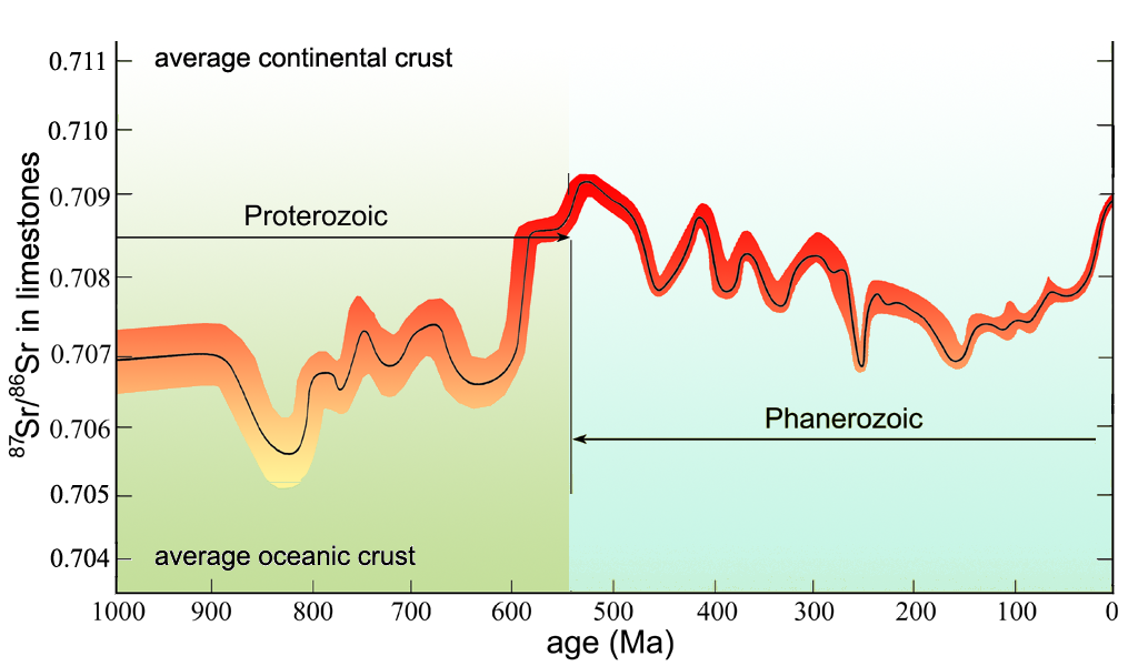 Figure 16.2 Average 87Sr/86Sr ratio in marine limestones through the Phanerozoic
Today the continents far outstrip oceanic crust in supplying dissolved strontium to the oceans, and there has been a rising trend for the last 150 Ma or so. In that time, the mountains of the Alpine-Himalayan chain, the Andes and western North America have risen been eroded and weathered. Supporters of this proxy method link each of the peaks on the curve to periods of topographic uplift within or on the flanks of continents, and therefore to the increased erosion and weathering such processes must encourage. So far so good; now comes the special part of weathering. The hydrogen ions that are essential for the breakdown of originally igneous silicate minerals are most abundantly released by CO2 dissolving in rain water (Chapter 2) to make it weakly acid. Summarised in a chemical equilibrium involving calcium silicate, this is what happens:
CaSiO3 + 2CO2 + 3H2O = Ca2+ + 2HCO3– + H4SiO4 (Eqn 16.1)
Both calcium and bicarbonate (2HCO3–) dissolve in water as ions, and that is how they enter seawater. There, various life-mediated processes combine the two to produce calcium carbonate – ultimately limestone or scattered fossils buried in other sediments, like so:
Ca2+ + 2HCO3– = CaCO3 + H2O +CO2 (Eqn 16.2)
Each equilibrium involves just a single calcium atom, so the net effect can be judged. For every two CO2 molecules involved in weathering, ultimately only one gets back into the atmosphere once carbonate is precipitated. Combined weathering and carbonate precipitation draws down the principal ‘greenhouse’ gas. But it is not merely calcium and bicarbonate ions that weathering releases. Accompanying them are the nutrients, principally potassium, iron and phosphorus, on which photosynthetic marine organisms (phytoplankton) depend. An upsurge in weathering fertilises the oceans so that life can bloom yet more dramatically, thereby increasing the chance of carbonate and dead-tissue burial. There are intricacies, for some carbonate is produced directly on land, helping to bind together soils formed by the combination of rock weathering and vegetation growth. Debris transported from rising mountains can bury such soils. Even when fresh debris is buried, acid groundwater drives the basic equilibria, to cement it together with carbonates. All three processes involve the burial of carbon, and form a powerful means of reducing the ‘greenhouse’ retention of incoming solar radiation. Plate tectonics, if it involves fortuitously colliding continents, seems to be a major influence on climate. Combining the drawdown of CO2 by weathering with the atmospheric effect of mountain belts and plateaux that coincide with Hadley convection, as in the current case of the Himalaya and Tibet, serves to amplify the influence dramatically. The increased elevation and monsoon precipitation drive each other inexorably.
Most erosion takes place in valleys, both by stream flow and, if elevation is high enough, by glaciation. By being stripped from narrow valleys, the removed mass is compensated by further uplift to restore gravitational balance. The valleys get deeper and the intervening ridges rise higher still, so explaining the 6-7 km depth of the Brahmaputra and Indus gorges, and the great heights of the Himalayas compared with the slowly eroding Tibetan Plateau, where low-density crust is equally as thick. Once initiated, the tectonic-climatic mechanism is self-sustaining, until it runs out of gravitational potential and erosion finally grinds the mountains down to their gums.
It might have crossed your mind that throwing up mountain chains must expose carbonates and organic carbon (coals and oily shales) from previous cycles of burial to the same agencies that extract CO2. So it does, but again simple chemistry shows that this does not balance the withdrawal by release. The action of weakly acid rain on carbonates does not make them fizz:
CaCO3 + CO2 + H2O = Ca2+ + 2HCO3– (Eqn 16.3)
Calcium and bicarbonate merely add to the supply of ions for biological production of carbonate in the oceans. Carbonate weathering probably has no balancing effect. Coal and hydrocarbons, if buried long enough to sufficient depth and warmth, lose water vapour and hydrogen atoms to become more and more carbon rich. While some micro-organisms relish partly matured coal and oil, in effect oxidizing it to CO2 and water, the higher the carbon content the less digestible it is. A great deal of exhumed organic matter is just ground down to be reburied, as a walk along a coastal coal-mining area will show nicely by its black, coal-dust beach sands.
There is one means whereby the CO2 balance is restored. Ocean-floor carbonate and organic carbon, mixed with clay and simple quartz in other sediments, ultimately descends subduction zones to be heated. Metamorphism recreates the starting materials for Equation 16.1, as I briefly described in Chapter 15 (Equation 15.1). Some of the ‘greenhouse’ gas may escape directly along fractures above subduction zones to reach the atmosphere. There has been little research to show the magnitude of this possibility. Undoubtedly, much becomes involved along with water vapour in mantle melting, to escape via the volcanoes of arc systems above. Would this not balance the drawdown by weathering? The answer is a qualified ‘No’. Transporting the deposits of buried carbon to subduction zones and then down them to the depth where such recombinations can take place takes time. Moving at the pace of growing toenails, the tectonic forces involved lag behind the onset of the weathering and erosion that elsewhere they have triggered by continental collision. Eventually the balance is restored, but not before the buried matter of earlier, different cycles enters the mantle.
As in all processes on Earth, those associated with tectonics are not isolated, particularly when climate and the carbon cycle are our focus. Volcanoes continually supply CO2, more often than not at slowly changing rates. Sometimes that rate is briefly boosted by extraordinary mantle upheavals in the form of basaltic lava floods. As well as the production of marine carbonates from dissolved calcium and bicarbonate ions, life’s role is important in another way, at least it has been for about 400 Ma. Carbon in organic form became available for burial on land once vegetation gained a hold there. Chapter 17 traces the main outcomes for climate over the last billion years from this convoluted array of interwoven influences.
Check out Further Reading for Part V to see source material and links to articles
If you enjoyed reading this chapter online and want to learn more, Stepping Stones is available to download as an eBook
