New from Snet: Lithologs, a new tool to create lithological/sedimentological logs online..
Posts treating: "Lahar"
Monday, 23 May 2016
Imaggeo on Mondays: Moving images – Photo Contest 2016
GeoLog-The official blog of the European Geosciences Union [2016-05-23 12:30:42]
 recommend this post
(158 visits)
recommend this post
(158 visits) 
GT,ID,GB,US,MY
Since 2010, the European Geosciences Union (EGU) has been holding an annual photo competition and exhibit in association with its General Assembly and with Imaggeo – the EGU’s open access image repository. In addition to the still photographs, imaggeo also accepts moving images – short videos – which are also a part of the annual photo contest. However, 20 or more images have to be submitted to the moving image competition for an award to be granted by the judges. This year saw [...]
recommend this post
(158 visits) Living with volcanoes, and learning from the past.
November 13th, 1985, is a date that is still etched in my memory. This was the day that the Colombian town of Armero was submerged beneath a catastrophic flood of volcanic rocks, mud and water; a lahar that had swept down from the summit of the volcano Nevado del Ruiz, erupting about 40 kilometres away. For days, terrible scenes of anguish and despair filled our television screens, as rescuers struggled desperately to help the survivors, and recover the many thousands of victims. Thirty [...]Mount St. Helens Lays Her Eruptive History Bare: Stratigraphy Viewpoint

January 26, 2015
A Comprehensive List of Mineral, Rock, and Gem ClubsThe-Vug.com Protecting Mineral Treasures at Larsemann Hills, AntarcticaEarth Magazine Video: 2007 Lahar at Mt. Ruapehu, New ZealandGeoff Mackley Melting Glaciers Increase the Flow of Carbon to Downstream EcosystemsUnited States Geological Survey Video: Eruption and Pyroclastic Flow at Colima VolcanoMashable Layoffs Begin at Marcellus DrillersCBS Local Alaska AirlinesFriday Field Photo – St Vincent, 1902
Today’s field photo is by Tempest Anderson, of the ‘Roseau Dry River flowing with Boiling Mud’, a picture taken in the aftermath of the May 1902 eruptions of the Soufrière of St Vincent. The full published caption explains the origins of this boiling mud – a phenomenon we now call a lahar: ‘This is a small streamTower Power And An Archean Gneiss
WATCH FOR ROCKS - Travels of a Sharp-Eyed Geologist [2012-08-30 10:00:03]
recommend this post
(55 visits)
Paleogene
recommend this post
(55 visits) 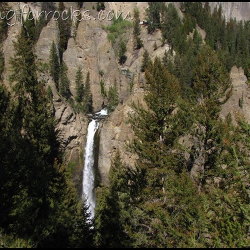
Volcanology Etymology
Jessica Ball has a blog post that explores the origin of some of the most commonly used words in volcanology – with some great photos too! How did we get interesting words like: lahar, caldera, ignimbrite, tephra, scoria,Activity at Nevado del Ruiz
Erik Klemetti reports on “Increasing Volcanic Unrest Observed at Nevado del Ruiz in Columbia” the volcano that produced a lahar in 1985 that killed over 20,000Cryptozoology and Cute Fuzzy Critters

Mt. Washburn – Fifty Million Years Later
WATCH FOR ROCKS - Travels of a Sharp-Eyed Geologist [2011-07-26 08:13:32]
recommend this post
(112 visits)
Paleogene
recommend this post
(112 visits) 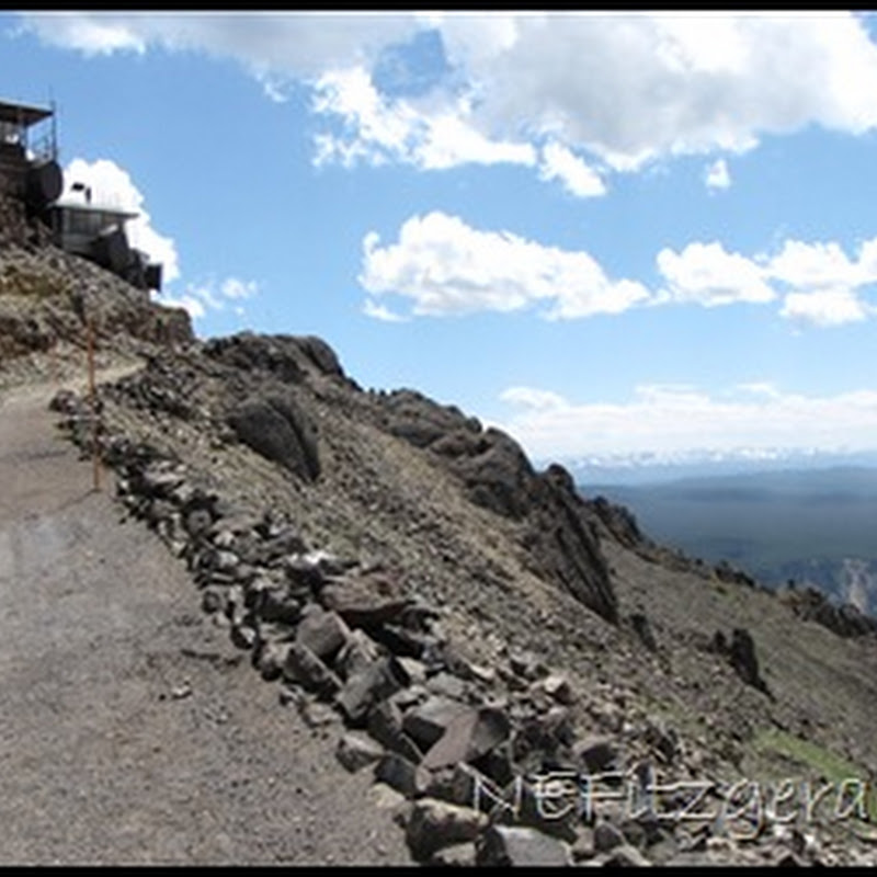
Columbia Basin Trip: Day 1 - a Lahar and an Anticline

Kamera-kamera Pemantau Lahar Merapi
Pemantauan lahar hujan secara “remote” dilakukan dalam berbagai cara. Sistem peringatan dini lahar Merapi yang sudah terpasang terdiri dari alat penakar curah hujan otomatis, kamera CCTV, dan geofon atau pemantau aliran dengan metode akustik yang masing-masing dilengkapi dengan sistem telemetri atau alat pengirim data secara otomatis ke stasiun pusat pemantau di BPPTK dan pengendali operasiNew at Erratics: from lahar to suevite
In his second post at Earth Science Erratics Simon Wellings reveals a rather interesting deskcrop, collected from Scotland in his youth: Since it was picked up, this rock has changed identities: what was once thought to be a mud flow … Continue readingEndapan Lahar Hujan: Dimana Diendapkan ?
Pada prinsipnya penanggulangan lahar hujan ini adalah pengaturan sedimen. Itulah sebabnya dalam kategori penanganan di PU, lahar hujan ini masuk dalam bencana sedimen. Secara mudah sedimen itu akan mengendap ketika alirannya melambat disitulah akan terjadi sedimentasi. Dengan demikian usaha penanganannya adalah mengontrol dimana kita akan meletakkan (mendeposisikan) material-material ini. Tentusaja akan diusahakan dimana dampaknya palingPembentukan alur-alur baru di lereng Merapi
Lahar hujan saat ini menjadi ancaman di sekirat lereng Merapi, terutama di seputar sungai-sungai utama yang berhulunya terdapat banyak endapan awanpanas. Kalau dilihat pada saat setelah terendapkan, maka Pembentukan alur baru di lereng selatan Merapi merupakan sebuah gejala yang tidak boleh dilewatkan begitu saja. Pengamatan perubahan morfologi sungai ini akan sangat membantu dalam mengantisipasi laharA Visit to White Island, New Zealand
White Island is a stratovolcano located about 30 miles off of North Island, New Zealand. A Pittsburgh Post Gazette writer reports on her visit to the island with a tourist group. The island is uninhabited. A sulfur mine was established on the island but the mine was abandoned in 1914 when a lahar killed allPeta antisipasi lahar hujan Merapi
Dibawah ini beberapa peta antisipasi lahar hujan dalam berbagai bentuk dan skala.Setiap kejadian selalu memiliki info penting selain diskripsi dari fenomena itu yaitu lokasi. Lokasi inilah yang diperlukan sebagai petunjuk untuk penanganan selanjutnya. Jadi kalau ada data apa saja, jangan lupa lokasinya. Saat ini sudah ada GPS bahkan dalam handphone. Cantumkan lokasi lat-long tsb dalamCold Lahars Displacing People at Mount Merapi, Indonesia

Cold Lahar Floods Hundreds of Homes in Yogyakarta
A cold lahar from Mount Merapi volcano flowed down the Code River, flooding hundreds of homes in the city of Yogyakarta, Indonesia. Related: Learn about lahars and other volcanicBahaya lahar hujan: erosi, sedimentasi dan suhu.
Jogja saat ini memang sudah masuk kategori aman dari erupsi Merapi. Walaupun Merapi masih dalam status AWAS, namun erupsinya sudah dalam taraf mendarat. Mbah Rono menyebutnya taraf landing. Kalau landing ya harus mulus supaya tidak terjadi goncangan. “Safe landing, happy ending ya, Pakdhe “ “Betul Thole, saat mendarat juga kadang ada goncangan kecil itu biasa.Top concepts:
Top posts:
- NOAA plot confirms continued global warming (96 visits)
- Sharp talon of cold coming to jab us (96 visits)
- Bolsilibros Mesozoicos (V): La conquista del espacio (94 visits)
- Further earthquake reading: Philip Fradkin (91 visits)
- Il film più politicamente corretto della storia (86 visits)
- Spring Clipper comes down on Toronto (78 visits)
- Regulating Air Toxics from Petrochemical Plants (76 visits)
- South Dakota Maples—Sugar, Silver, & a Trickster (69 visits)
- TURTLE SHELLS: HOME SWEET ARMOUR (68 visits)
- Greenhouse effect (67 visits)
Ads: