New from Snet: Lithologs, a new tool to create lithological/sedimentological logs online..
Posts treating: "hikers"
Thursday, 26 May 2016
Living the Dream, Day 5 – Bright Angel and Beyond
WATCH FOR ROCKS - Travels of a Sharp-Eyed Geologist [2016-05-26 01:13:44]
 recommend this post
(190 visits)
recommend this post
(190 visits) 
US,CA
recommend this post
(190 visits) 
Flyover Country—The next generation field-based research tool
In December 2015, with the support of a National Science Foundation (NSF) EAGER grant, the Flyover Country (FC) team of Amy Myrbo (University of Minnesota Research Associate), Shane Loeffler (2015 B.S. graduate of the University of Minnesota Duluth), Reed McEwan (University of Minnesota M.S. in Geology and Software Engineering) and Sijia Ai (University of Minnesota), launched FC as a geosciences mobile app for air travelers, road warriors andPucker-worthy Debris Flow Video
I saw this video a few weeks back on The Landslide Blog, and it's also been posted on GeoEngineer.org. It's well worth the watch. It's one of the scariest debris flow videos I've seen. Some hikers are crossing a channel cut naturally through old debris flow deposits, like a hiker bowling alley. Fortunately the guides hear it coming and everyone manages to get out of the channel before the latest debris flow roars through! [Source: YouTube via Dave's Landslide Blog. Image:Friday fold: Yin-Yang at Swift Dam
What is Matt looking at here? Matt was one of my Rockies students this summer, a geology major at the University of Virginia. Together with another UVA student and students from Mary Washington University and George Mason University, Matt embarked on a mountain-climbing hike during our evening camping at Swift Dam, near Depuyer, Montana. The hikers were treated to an extraordinary sight when they attained the summit: Click to embiggen;Phreatic eruptions – the silent assasins
The recent eruption of Mt Ontake, Japan tragically killed at least 50 hikers who were on the volcano at the time. Within hours of the eruption taking place, social media was flooded with first-hand video footage illustrating just how close many survivors came to perishing in an onrushing pyroclastic flow. Despite having a sophisticated seismicOn Japan’s Mt. Ontake volcano, a perfect day turns deadly for hikers
latimes.com It was a perfect fall weekend, with sunny skies and the prospect of colorful autumn foliage. Hundreds of people flocked to Mt. Ontake in central Japan, planning to hike to its volcanic summit. READ MORE Japan’s Mount Ontake Erupted Suddenly Over the Weekend smithsonianmag.com Over the weekend, the Mount Ontake volcano—a popular hiking spot in10% of Iceland Closed as Concern Over Volcano Grows
Concern is increasing tonight that the Bararbunga (BOWR-Thar Boon-Ka) volcano may be getting ready to erupt. Earthquakes continue, and these type of quakes indicate that magma (Lava with high pressure gases) is moving beneath the volcano, which is much larger than the one that caused serious air travel disruptions a few years ago. Late today, Icelandic officials declared about 10% of Iceland off-limits, and is evacuating residents, hikers and campersSnow photos sought to illuminate snowmelt puzzle
In some places, where trees protect snow from sun and wind, it actually melts faster than in open areas. That’s what scientists concluded recently when they did a review of global data about snowmelt. Now, to gather much more data needed to deeply understand the discovery, and to make it useful for land and forest management, those same scientists are reaching out to an unlikely pool of collaborators: hikers, forest managers and other outdoors enthusiasts throughout the PacificPhotos: Hiking Wire Pass and Buckskin Gulch
Some of Utah’s finest features—our slot canyons. ksl.com Wire Pass and Buckskin Gulch are both beautiful slot canyons in southern Utah and hikers can access both of them from a single trailhead. READOkama Crater Lake Known to Change Color
Mount Zao in Japan is a popular destination for skiers and hikers year-round. During the winter, many come to see vertically piled heaps of snow that collect around the mountain.[...] The post Okama Crater Lake Known to Change Color appeared first on LakeVancouver Island's West Coast Trail - A Trip Into the Green - Part 1

Going Hiking In Pangaean India

Satellites Rescued 207 People in 2011
“In 2011, NOAA satellites were critical in the rescues of 207 people from life-threatening situations [...]. The satellites picked up distress signals from emergency beacons carried by downed pilots, shipwrecked boaters and stranded hikers, and relayed the information about their location to first responders on the ground.” Quoted from the NOAA pressRocking Along The Rim
WATCH FOR ROCKS - Travels of a Sharp-Eyed Geologist [2012-01-09 17:20:42]
recommend this post
(39 visits)
recommend this post
(39 visits) 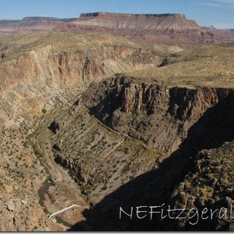
Grizzly Bear Kills a Yellowstone Hiker
Hikers in Yellowstone National Park surprised a female grizzly bear with her cub. The threatened bear killed one of the hikers. Related: Staying safe aroundMount Washington 5: glacial features & views
Busy days here in DC and northern Virginia… Blogging time has been limited. A few more shots from this past summer’s time at Mount Washington, to fill the void… Prius atop mountain: The Great Gulf: Hikers in relatively warm weather: Another look down the Great Gulf: Glacial cobble of diorite, exotic to the top of the Presidential Range, and therefore icily transported there from a distant source. Mount Jefferson, as12 October, 2007: Rock fall at the Einser

Hawai`i in Iceland: The style of the Eyjafjallajökull-Fimmvörduháls eruption
The eruption at Eyjafjallajökull-Fimmvörduháls continues on - the explosive spatter and bomb eruptions at the new central vent (on the second fissure) were impressive all night, making the hikers/cars/aircraft look like mites in comparison. This eruption has, so far, followed the pattern of Hawaiian-style volcanism quite well, so I thought it could be a good time to talk about what exactly Hawaiian-style volcanism is. There is a sequence of events that leads up to and follows the start of an [...]Monday Musing: Iceland update, false alarm at Taal and the SI/USGS Weekly Report
Quick hits for a Monday morning (however, the week did have a good start). Lava fountaining on March 27, 2010 at the Eyjafjallajokull-Fimmvörduháls eruption in Iceland. The Eyjafjallajokull-Fimmvörduháls eruption is still going strong with two active fissure - and a lot of tourists poking around as well. If you watch the webcams closely, you can even see the cars and hikers trekking up near the erupting basaltic fissure (except today, as there seems to be a blizzard). Not to say that [...]Where on (Google) Earth #185
A message from Erwin Sevens: As a incidental visitor, wandering through geology related webpages, I stumbled upon the WoGE 184 contest. Intrigued by the beautiful phenomenon shown on the image and loving to browse around the planet with the Google Earth application, I could not resist trying to find out where it was located. So, with a little bit of luck, I pretty quickly found the location in Bolivia. The "crater" like structure is a synclinal depression formed of Cretaceous sediments [...]Top concepts:
Top posts:
- Sharp talon of cold coming to jab us (110 visits)
- NOAA plot confirms continued global warming (106 visits)
- Bolsilibros Mesozoicos (V): La conquista del espacio (99 visits)
- Il film più politicamente corretto della storia (99 visits)
- Further earthquake reading: Philip Fradkin (98 visits)
- Spring Clipper comes down on Toronto (90 visits)
- Regulating Air Toxics from Petrochemical Plants (81 visits)
- South Dakota Maples—Sugar, Silver, & a Trickster (79 visits)
- Greenhouse effect (78 visits)
- TURTLE SHELLS: HOME SWEET ARMOUR (74 visits)
Ads: