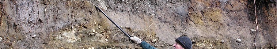


I visited Point Whitehorn on July 5- its a wonderful wild beach managed by Whatcom County Parks. I updated the field trip (visit it here: https://nwgeology.wordpress.com/the-fieldtrips/point-whitehorn-whatcom-county/ I originally published in 2009 ( the wordpress link inserter doohickey isn’t working so cut and past the url into your browser) . There have been no really major changes but I added a couple of pictures, a bit about the 1957 bulldozer effort to halt wave erosion (hint- you can’t stop geology) and took a careful look at the progress of undercutting at the

Google Earth image clearly shows boulders aligned by a bulldozer at the base of the bluff. This is about 1/5 mile northwest up the beach from the where the trail reaches the shore. The white bar is 100′ long. A low tide uncovers dozens of big erratic boulders on the sandy beach and just off the shore.
base of a giant erratic eroding out of the glacial till in the bluff. Highly recommend you visit this place if you haven’t before. It’s one of my favorites. A variety of glacial and periglacial sediments in the tall bluff, lots of cool boulders and cobbles on the beach. At low tide a big sandy beach as well, and views across the Strait of Georgia to the San Juan and Gulf Islands. The beach is reached in a 1-mile flat stroll through the woods before you drop down the steps to the shore. Go at low tide to examine the many offshore erratics and intertidal marine life.
Filed under: Bellingham area, geology, Geology field trips, glacial erratics, glacial geology, Glacial stratigraphy, shoreline geology | Tagged: Beach geology, erosion, erratics, Glacial deposits |

Many thanks for the information! Vicki
>
Good morning. The link seems to go to page not found.
Hmmm. It works for me. Is anyone else having a problem with this link? Dave
These are so cool! Thank you for these.