

Dear friends,
It’s been a while since I posted any geology. I saw some really cool stuff in Europe during my 5-week trip in July and August. I primarily visited Iceland, northern Italy, and London with a couple nights each in Munich and Innsbruck. I will share the two significant geologic highlights. The first was a hike to see the Litli-Hrútur basalt eruption in Iceland, the other to the famous 65-million-year-old Cretaceous-Paleogene ‘dinosaur’ mass extinction layer in Gubbio, Italy. I’ll post that one separately.
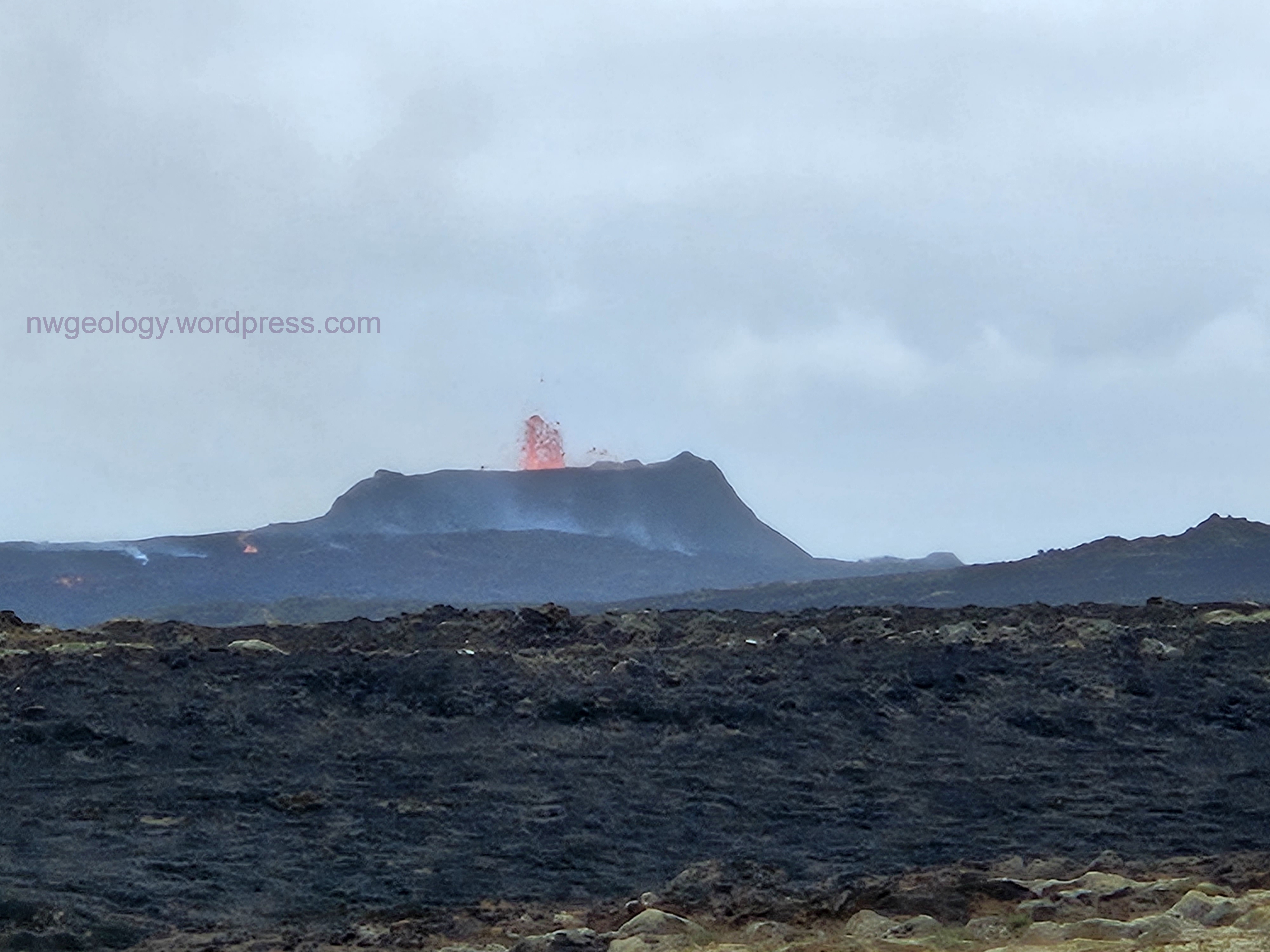
Lava erupts in a fountain above the spatter cone at the 2023 Litli-Hrútur eruption on the Reykjanes Peninsula, Iceland. photo by D. Tucker
ICELAND- July 25, 2023 Litli-Hrútur eruption!
I started planning a trip to Iceland with my partner Grace and her son Miles last winter. We were so fortunate to be there when the Litli-Hrútur eruption was underway, in an area we already intended to visit. We caught it midway in it’s short life (July 10-August 5, 2023). We hiked 5 miles (and then back) on a newly-made emergency track to view the erupting spatter cone and the advancing lava. There were hundreds of other curiosity seekers from all over the world making the trek. You can see great photos and video on the interwebs. Just search for ‘Litli Hrutur eruption’. These two vids are particularly good and don’t have those annoying ads at the start. I have a link at the bottom of this post to the two short videos I uploaded.
I will write about my experience. The Litli-Hrútur eruption was in the Reykjanes Peninsula, the southwestern-most part of Iceland, where the mid-Atlantic ridge surfaces onto land. It was the third basalt eruption in the area in a 3-year period (see image below). The others resulted in the Geldingadalir flow in 2021, and the Merardalir flows in 2022. All three lavas are contiguous, and are broadly associated with the Fagradalsfjall volcano on their west margin. (As I write this, there is concern about yet another eruption near the town of Grindavik, 5 miles to the west on the opposite side of the Fagradalsfjall volcano.)
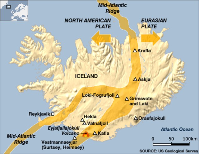
Iceland’s volcanic zones. The Reykjanes Peninsula, south of the capital city of Reykjavik, is the landward extension of the Mid-Atlantic ridge.This is the divergent plate boundary between the North American and European plates. Global Volcanism Program, https://volcano.si.edu/volcano.cfm?vn=372020 https://volcano.si.edu/volcano.cfm?vn=372020
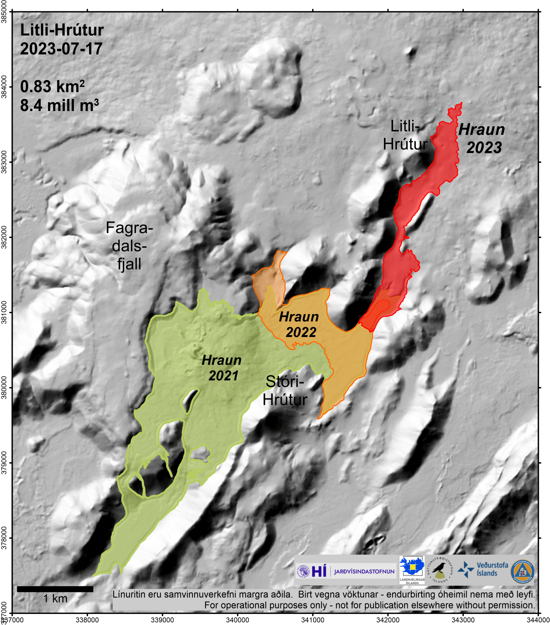
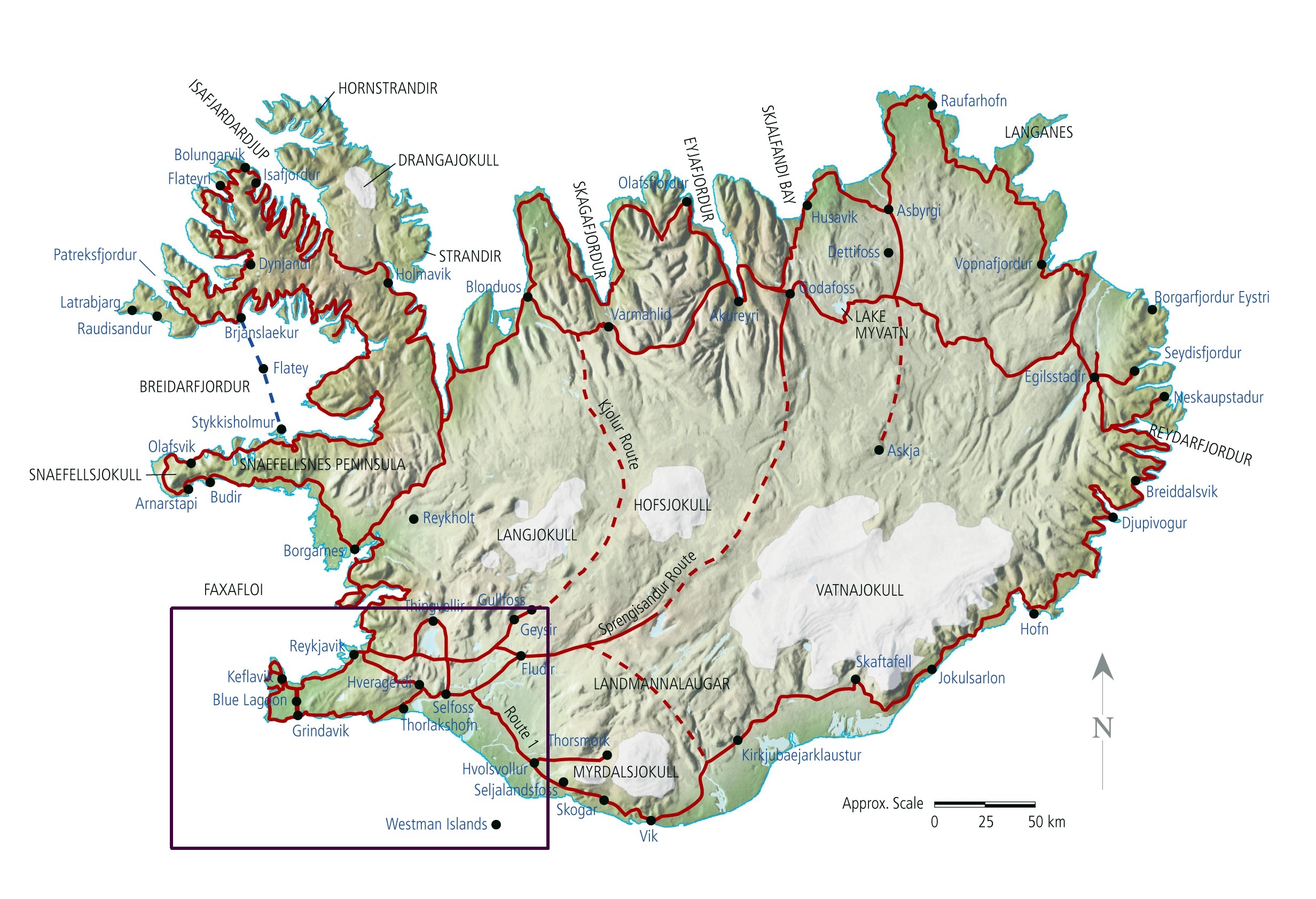
Zooming way in, here is the distribution of the three youngest eruptions on the Reykjanes Peninsula- note the scale bar in bottom left.. ‘Hraun’ is Icelandic for ‘lava’. The 5-mile road hike hike begins just off the south edge of map, and runs along the flat area east of the hills bounding the eastern margins of the three flows.
All three eruptions began as fissures emitting fountains of lava. At Litli-Hrútur, and the others, the eruption eventually concentrated at singular points along the fissures. Lava erupted into the air and fell back to form fragile spatter cones. Fountaining continued from this central vent, and lava flowed outward along topographic lows. All three eruptions became huge tourist draws. Trails were made to safely
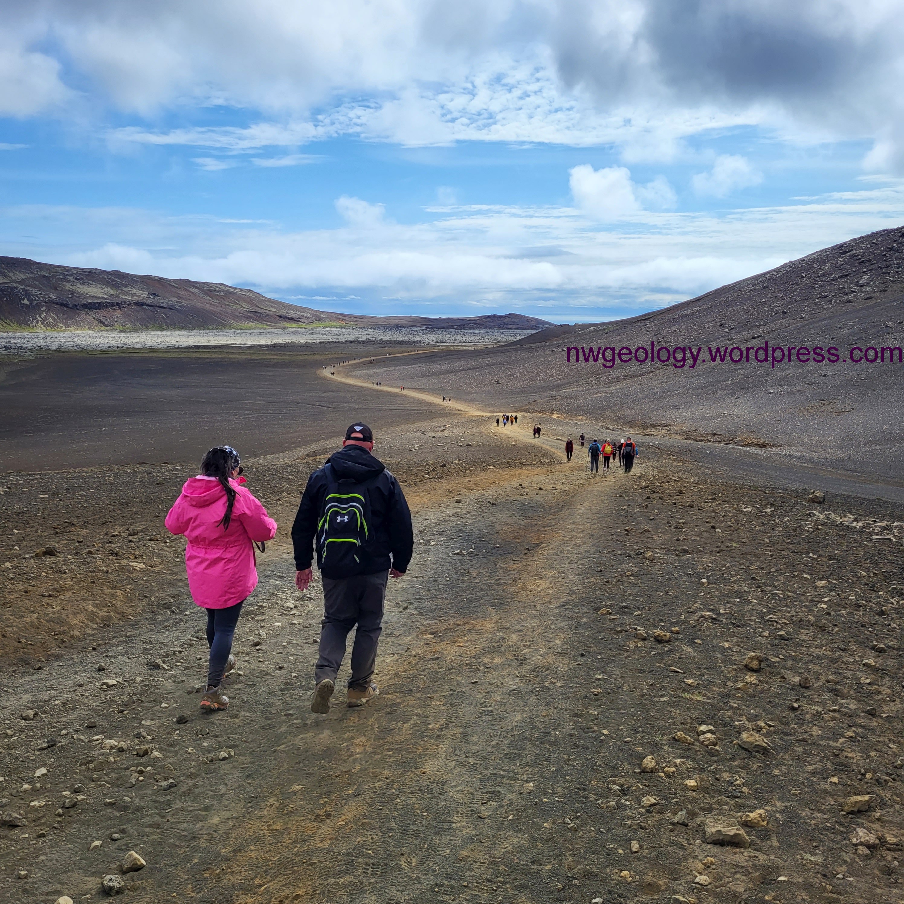
It seemed a long way in across a lunar landscape to the Litli-Hrútur eruption. A lot of people from all over the world were making the trek. Many seemed ill-prepared for a change in the weather- it can get wet and cold here in a flash. Photo by D. Tucker
accommodate the crowds. Rescue teams were stationed in the area and were occasionally called on to rescue yahoos, dumb asses, and lost souls- the weather can be atrocious and the barren topography confusing if you step off the track. The roads were bulldozed to allow safer access for the tourists, the rescue teams and- ready for this?- fire engines. No, not to ‘put out the eruption’ but to extinguish moss fires. The eruptions occurred on older, in places moss-covered lava flows- moss is just about the only vegetation in this wild corner of Iceland. Advancing lava ignited the moist moss (everything is damp in this area) which would smoulder rather than flare up. The clouds of choking smoke stank at least as bad as the gas coming off the lava.
After trudging nearly five miles, we turned a corner and suddenly ahead of us in the distance was a
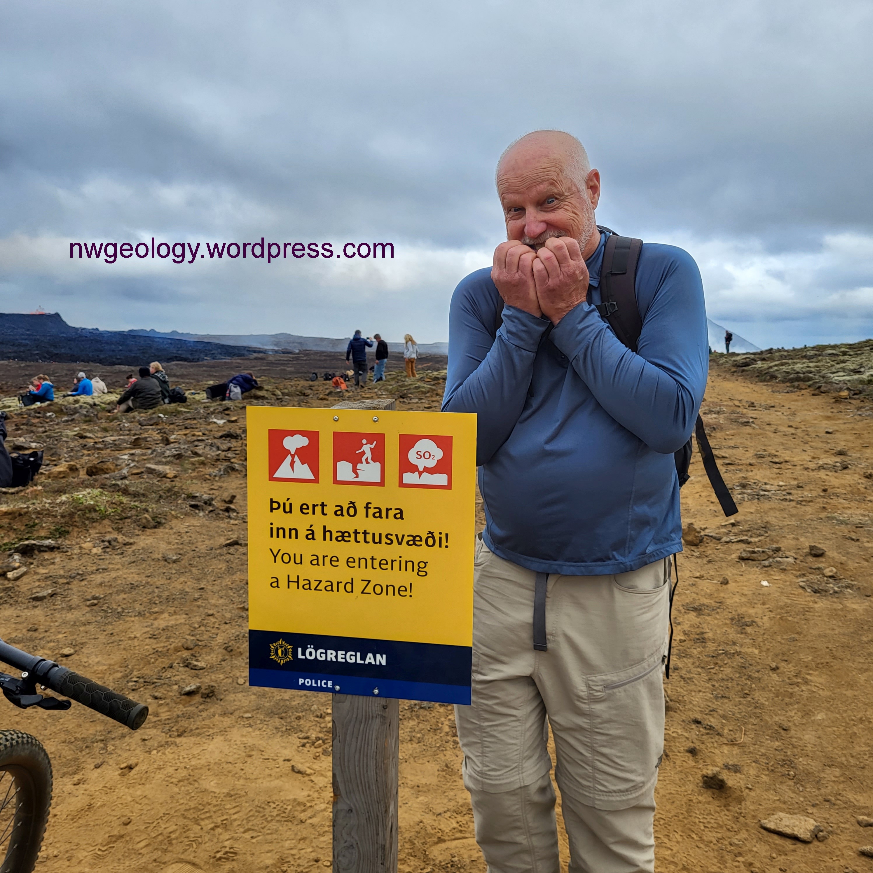
Uh…like, it’s a volcano, you know? I guess some people need to be told. photo by M. Remmel
sudden spray of incandescence leaping above an insignificant bump. We didn’t know we were that close; it was really thrilling. But we continued on and it got even better! The road ended at a temporary fire department shed and the track continued across an older rough lava surface- covered in thick, charred moss. The trail was boot-beaten and ankle-twisting but short. It ended at a small rise a couple hundred meters from the eastern edge of the black, oozing lava flow. The flat-rimmed spatter cone (see the first photo in this post) rose maybe 20 meters above the lava less than a half-mile away. We couldn’t see inside the cone, which was filled with a turbulent lake of magma. The people standing on top of the hill known as Litli-Hrutur (‘Little Ram’) on the opposite side of the flow did have a view into the cone, but were much further away from the lava, and had a lot longer and more complicated hike to get there. And they were downwind of the nasty sulfurous fumes from the erupted magma. I was real happy with where we were.
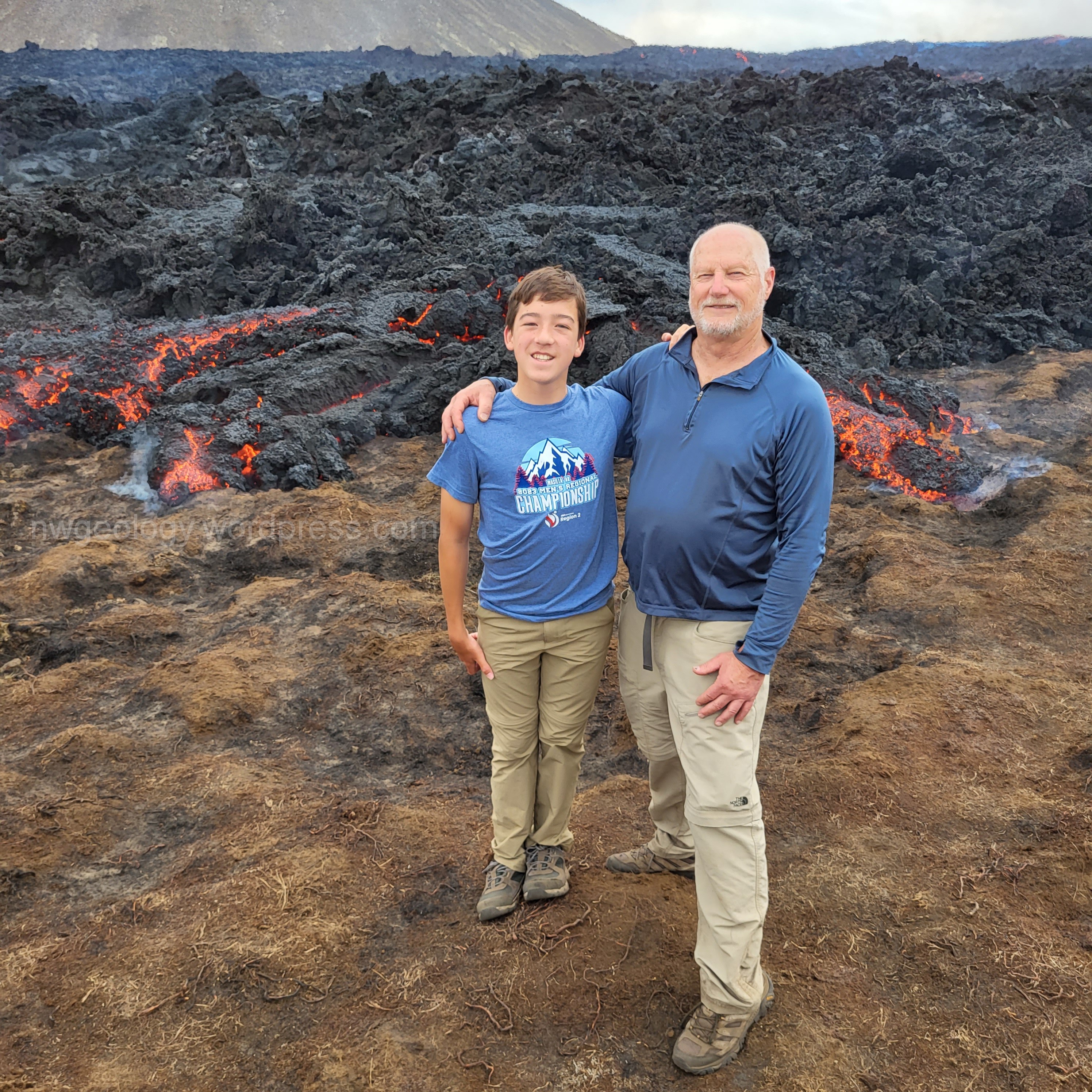
About as close as Miles and I could stand to the advancing lava for any longer than it took for a photo.
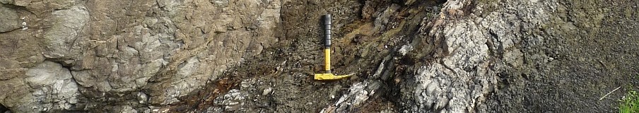
Miles and I picked our way across lava blocks covered in blackened moss to join the crowd at the lava’s edge- well, not right at the edge, it was too dang hot to stand less than 3-4 meters away. The lava was around 1100 C (2000 F) and I felt my face burning if I got any closer. Incandescent lava showed in cracks in the black crusted flow surface, and small blobs of glowing lava made short incursions beyond the flow margin. This is type of viscous, rough-surfaced lava is called a’a, a Hawai’ian term for, well, slowly moving, lava with a rough surface. It’s used in contrast with pahoehoe, meaning less viscous, smoother surfaced lava that advances a bit faster. Miles tossed a rock into what he assumed was soft, gloopy lava and was surprised when it bounced off- the lava is flowing, maybe like thick pancake batter, but it is not soft. The surface, even though glowing hot, has a thin, hard skin. (This website https://www.nps.gov/articles/000/lava-flow-forms.htm has a lot of good photos and explains the difference between a’a and pahoehoe; it’s very thorough but you can cut to the chase.)
We reluctantly left. The weather looked a bit threatening, and we had to retrace the 5 miles to the rental car and continue on our drive to our guest house near the town of Hella. I kept tabs on the eruption daily after we left Iceland, and was kinda sad to see the eruption waning and eventually ending 10 days after our visit- I had contemplated a quick stop over on the way home. At the end, the lava flow was less than a square km in area, about 3 km long and at the most 0.5 km wide. The total volume erupted was 8.4 million cubic meters. We felt incredibly lucky to have been in Iceland for a few days just when we were. We saw other cool stuff in Iceland (so much to see!) but I won’t post on it pending a return when I can spend MUCH more time in this geological paradise.
If this area erupts again it’s worth making the trip to check it out; the whole country is fabulous but I probably don’t need to tell you that if you are in to geology. Its a 7-hour flight to Iceland from Seattle. Car rentals are easy (but I hope you can drive a stick) and the Reykjanes area is less than an hour drive from the international airport in Keflavik. So future eruptions in this area could be relatively simple to visit. I talked to a guy from Boston who was making his second weekend visit to the eruption- he rented a car and a mountain bike and rode the track in a fraction of the time it took us to walk. He didn’t even stay in a hotel, just slept in his car and on the flight either way. He was back to work with his unionized job (subtle hint), driving a subway train on Monday morning. Ho hum.
See two short videos I took of the lava flow and lava fountains on my YouTube channel. After you open these shorts, click the bottom gray button to open my description of what you are seeing.
https://www.youtube.com/channel/UCQb9D3XviLvPT1BYIg7N7NA
Stay tuned for the next post, about my visit to the famous ‘dinosaur’ mass extinction layer near Gubbio Italy- it’s on many a geologist’s bucket list
Filed under: geology, News and notes, volcanic activity, Volcanic rocks, volcano hazards | Tagged: adventuretravel-travelbucketlist-hiking-trekking, basalt, eruptions, Iceland, lava flows, Litli-Hrutur, overseas-adventure-travel, travel, volcanoes |

Hi Dave, quite the trip I would say. I am glad you had fun.
‘If you’re not having fun, you’re not doing it right’. Don’t know who said that, some sage person, probably from the 1960s. 🙂
Hi Dave, Great report and videos! Thank you! I am curious, would like to know: When the plumbing for these volcanoes, for this rift, eventually pull apart and cool off, and then if ever uplifted would they be an ophiolite? Was something like this the origin of the ophiolite exposed at Fidalgo? I keep re reading your book, Geology Underfoot. I retain a bit more each time. There is a huge amount of info in there, I guess you knew that! Anyway, it’s very coherent, and I’m glad you wrote it. peg ferm
Thanks Peg, and hello. It’s been a while. That’s a good question. Deep thinking- so to speak. Yes, this is essentially sea-floor basalt, it’s just erupted onto land. So an ophiolite sequence could be expected if we could ever see deep enough. However, ophiolites are generally exposed by erosion of sea floor accreted during subduction at convergent plate boundaries rather than divergent ones like on the Reykjanes Peninsula. And that accreted plate fragment has to include some of the mantle, down in the lowest regions of the plate. I think something unusual would need to occur here to uplift the plates in this rift zone really high in order to then erode deeply enough to see the full crustal thickness. I can’t think of a geologic process short of accretion that would allow that. If anyone else can, let’s talk about it. Dave
Thank you! Yes, I see what you mean. To get lifted up it would have to be very positively confronted with a continental plate and there’s currently none in the neighborhood! Thanks!
peg
Great trip. It’s always nice to get a close-up. Not many chances.
Yeah, Wes, that’s why retirement and a geo travel nest egg in savings is a good idea.
Dave. I have your book and have done some of the walks/hikes. I love it. And, it is wonderful to read your post here. I was in Iceland June 2022 including the Reykjanes Peninsula, and, of course, just missed the eruption in August. I am hoping to return in Summer 2024 and your post rekindled the excitement. Be safe.
Kathleen Myers
Kathleen- better luck this coming summer! DT
[…] I visited the Iceland eruption last summer! December 8, 2023 […]